U.S. Breaks 1,853 Heat Records this Week. Topsy-Turvy Forecast for Father's Day Weekend
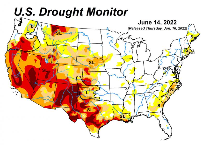
The U.S. Drought Monitor map tells an updated story every Thursday about the haves and the have nots – those farmers who have adequate moisture to fuel crops and those who don’t. This week, more Corn Belt farmers found their fields moving into the latter category.
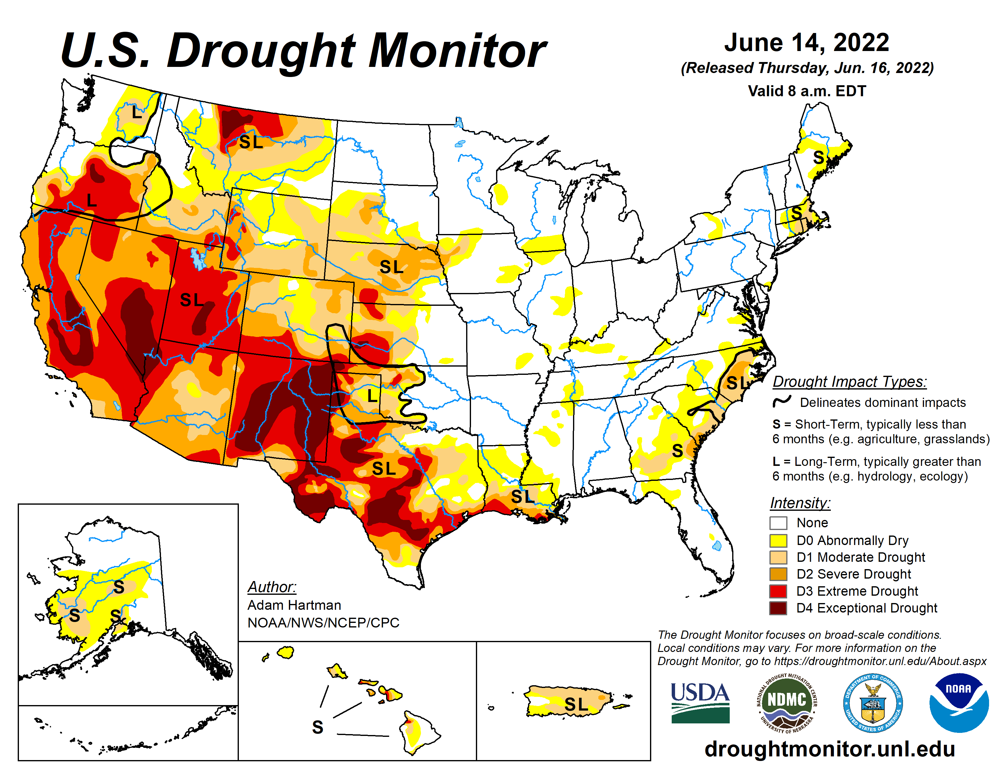
USDA meteorologist Brad Rippey says the intense ridge of high pressure that’s contributed to increased heat and less moisture in the past week is starting to affect more regions. Until now, those conditions have prevailed mainly in states in the West and Southwest.
“There are some parts of the country that are perhaps heading toward a flash drought, including some areas in the Corn Belt that to this point have not had any drought yet this season,” Rippey says. “You're not going to see this drought on the map initially – it's just going to be painted yellow with that abnormal dryness.”
Yellow pockets of color, indicating dry soil, are showing up in central and northern Illinois, southeast Iowa, southern Minnesota, southern Wisconsin, southeast Missouri and a handful of counties in southern Indiana.
However, this week’s Monitor does show some localized moisture improvements in the U.S., including just east of the Rockies and also in parts of the Southeast, notes Matt Yarosewick, AgDay meteorologist.
“It’s extremely damp still in southern Florida and across parts of the Mississippi River Valley, even up into the Ohio Valley, as well,” Yarosewick says.
Topsy Turvy Forecast
On Friday afternoon, the National Oceanic and Atmospheric Administration (NOAA) issued its short-range weather predictions for the weekend:
- Approaching cold front to ignite scattered showers and storms from the mid-Mississippi Valley to the Southeast coast this evening and lead to stormy weather in Florida/Gulf Coast States on Saturday.
- Unsettled weather located across the West with showers and thunderstorms impacting the northern Great Basin/Rockies, Central/Southern Rockies and Southwest, while a Critical Risk of fire weather remains in place over parts of the Great Basin into the Southwest through Saturday.
- Dangerous heat persists across the Deep South this Father's Day weekend, while also building into the Central and Northern Plains.
Heat advisory warnings were issued on Thursday for an area stretching from Kansas to West Virginia and between Indiana and Florida, according to Jim Wiesemeyer, Pro Farmer Washington analyst. He reports the U.S. has seen more than 1,853 heat records broken in just the past seven days alone.
What’s partly in play is the jet stream is farther north at this point than its typical, average position for June/July, explains Eric Snodgrass, principal atmospheric scientist for Nutrien Ag Solutions, in his weekly Weather Intelligence Report.
“This is also the reason for the above-average temperatures forecast for most of the U.S,” he says.
The NOAA reports May 2022 was among “Earth’s top 10 warmest months,” and that 2022 is the sixth-warmest year on record so far.
Looking Ahead
Snodgrass says his forecast models favor more “persistent ridging” anchored over the Midsouth, Midwest and Plains during the next couple of weeks and into July. He says he is most concerned about flash drought occurring in the Midsouth.
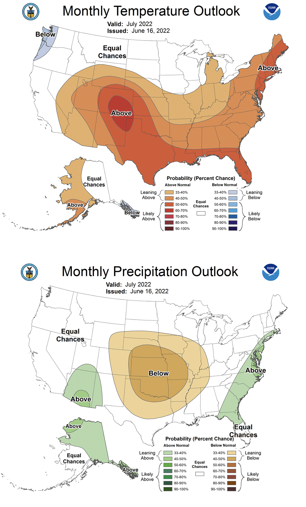
Rippey adds he believes the dryness could continue to build in parts of the central and eastern Corn Belt and the Southeast between now and the first of July.
“There are many areas of the country that are currently on the Drought Monitor with no color that could show up as yellow in the next week or two,” he says. “And that could rapidly progress into drought within weeks if hot, dry weather persists.”
Could the High Heat Cause Corn Prices to See a Repeat of 1988 and 2012?
Did High Heat And Humidity Really Cause Cattle Deaths In Kansas? The Latest Look at Potential Losses
This Week's High Heat Brought On By Ridge of High Pressure, Is It a Warning Sign of What's to Come?