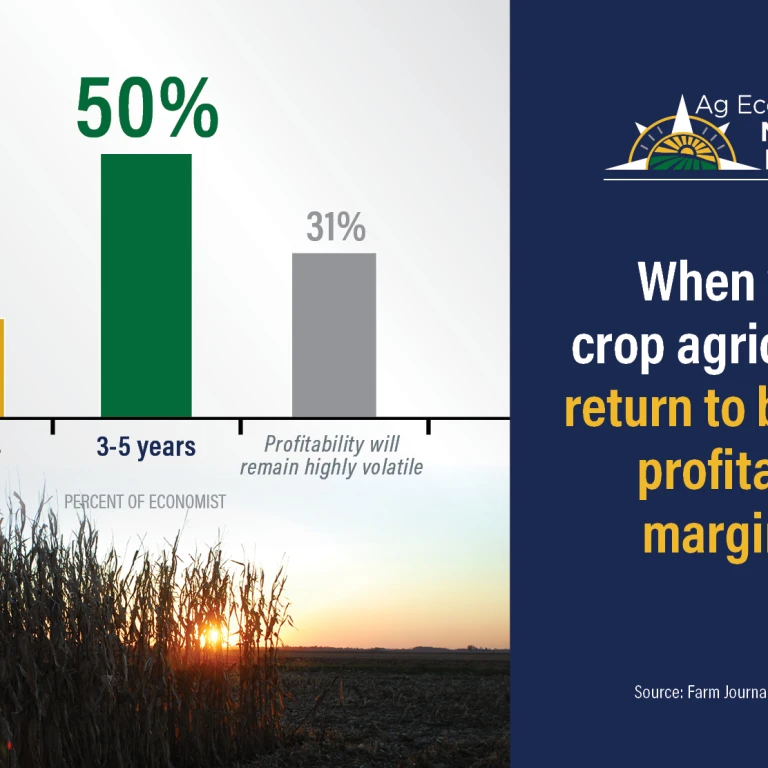
USDA’s Joint Ag Weather Facility says in the Corn Belt, a mix of rain and snow is falling across the upper Great Lakes region. “Markedly colder air is sweeping across the western Corn Belt, while warmth lingers east of the Mississippi River,” USDA explains. Showers and a few thunderstorms are occurring near the boundary between warm and cold air. Michigan leads the Midwest in topsoil moisture rated surplus—59% on April 23, according to USDA.
In the West, USDA says warm weather is returning to the Desert Southwest, but chilly conditions linger throughout the Rockies and Northwest. “In addition, showery weather across the northern half of the western U.S. continues to limit spring wheat planting and other fieldwork,” USDA details.
On the Plains, USDA reports very cool weather prevails in the wake of a departing storm system. “Light freezes were noted this morning as far south as the central High Plains, while readings near 20°F were reported across parts of the northern Plains,” USDA details. Snow covers the ground early today in portions of western South Dakota and environs, it continues.
In the South, USDA says residual lowland flooding is occurring in North Carolina and southern Virginia, following recent downpours. “Meanwhile, a strong cold front is surging into the mid-South, accompanied by showers and thunderstorms,” USDA continues. Elsewhere, warm, dry weather favors fieldwork and a rapid pace of crop development, according to USDA.
In its five-day outlook, USDA says colder air will continue to engulf much of the nation, except for warmth across the South and East. During the weekend, warmth will prevail in the eastern U.S. and return across the Far West, USDA reports. Across the nation’s mid-section, however, weekend freezes could occur as far south as the central and southern High Plains, possibly preceded and accompanied by wet snow, according to USDA. “Farther east, locally severe thunderstorms can be expected at times in the mid-South and environs,” USDA continues. Five-day rainfall totals could reach 2 to 6 inches or more from northeastern Texas into the middle Mississippi Valley, USDA explains. “Elsewhere, dry weather should be limited to Florida, North Dakota, and an area stretching from California into the lower Rio Grande Valley,” it continues.